WHAT IS THIS HIERARCHIZATION OF STREETS AND WHY IS IT FOR?
To build navigational order in the city, you need to look at it holistically.
And that’s what we do. We find the main arteries and representative roads, decide which streets and sections are more important and should stand out from the rest. Most often, these are streets leading to the heart of the city or to important attractions. You can build a hierarchy by distinguishing, but how can you distinguish streets from each other?
There are several tools for this. You can vary the color temperature of lanterns, you can diversify the shapes of lanterns and fixtures in specific areas, and it is also possible to differentiate the colors of poles. You can add additional lighting effects, such as a light veil – delicate illumination of facades, decorative projections, decorative navigation light.
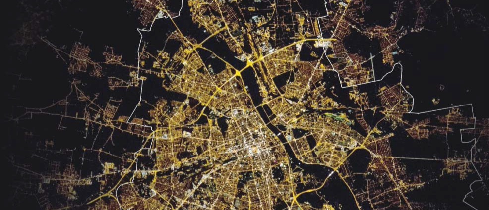
AERIAL VIEW OF THE CITY OF DA NANG (VIETNAM).

You can notice that the housing estates and tight street grids – smaller residential streets are lit with warm light, while the long avenues running to the heart of the city are treated with cool light. Also, more important streets – where “city life” takes place – are lit much more intensely than “sleeping” streets.
It all depends on a given specific space – the spirit of the city. For example, in Świnoujście, we decided to distinguish districts with extremely different character and highlight the city’s arteries not only by distinguishing the light temperature but also the colors of the masts.
The concept of modernization of urban lighting in Świnoujście was prepared taking DNA rules, including: rule 1 – essence; rule 2 – order of frame types and mast colors; rule 3 – lighting order; rule 4 – arrangement with light; rule 5 – Eco-lighting.
It was assumed that rule 1 – essence – should highlight the spirit of the place – Świnoujście, a multi-faceted and multi-threaded city. Its implementation included exposing communication routes leading towards the sea and the promenade, distinguishing urban spaces – the center and its surroundings by exposing the water panorama of the city and enabling the perception of important city objects at night.

Rule 2 provides for highlighting communication routes that are important for the perception of urban space by using characteristic types of fixtures and colors of street lighting masts in designated zones. In the case of Świnoujście, five spatial zones have been identified that can be distinguished using lighting technology, i.e.:
- zone 1 – undeveloped areas, access roads, areas on Karsibór island,
- zone 2 – the center area and main access roads to the center,
- zone 3 – residential areas,
- zone 4 – coastal areas,
- zone 5 – resort.


According to rule 3 – lighting order – it is planned to provide individual spaces of the city with lighting with a given color temperature (in the range from 2200 to 5500 K) and the method of light distribution. This action is aimed at strengthening the features of selected areas, enabling spatial orientation for users.
This solution was suggested by the existing situation in the city and its specific character. Poznań was treated differently. There, the larger the streets, the larger the masts, and the more modern the district, the more minimalist the lighting.
The principle of emphasizing zoning resulted from the observation that Poznań is characterized by a clear division: Peripheral areas – with numerous greenery and clusters of single-family buildings, a zone with block housing estates, a non-central zone where quarter buildings with a clear sight line begin, and a central zone including the Old and New Town, which is preceded by an urban development – Stübben’s Ring.

Each of these zones has characteristic features that should be emphasized in the night image of the city. In practice, this means using very warm light in the city center, including Ostrów Tumski and Wzgórze Przemysła. The further you go, the temperature increases from 2200K to 4000K. Warm downtown, squares, markets and representative roads. Cool light on the Stübben Ring and other traffic rings. Neutral light for the remaining spaces of the city – housing estates. Additionally, the way of presenting lighting was distinguished. The Old Town, Ostrów Tumski, in reference to its historic character, was to remain with low light points, historical lanterns, and fixtures both in the form of lanterns and mounted on the walls of buildings. Some irregularity, diversity and organic rhythms of the lighting fixtures and lighting of the sloping roofs of the tenement houses were allowed. New Town, on the other hand, means uniformity, a veil of light, neutral light color, high light points, rhythmic positioning of luminaires, spaciousness and simplicity.
When creating a hierarchy of streets, we listen to the needs of the city, its inhabitants, and safety considerations, but we also read the microclimate of the place and want to capture its essence.
Below is an example of building navigation consistency.
THE CITY OF DUBAI SEEN FROM A BIRD’S EYE


Here we see the opposite situation. The main thoroughfares are exceptionally warm, then each district (probably due to its purpose – residential/shopping/industrial district) is filled with cooler light. However, we can see quite a wide temperature range here, as you can see “yellow” quarters as well as white ones, or even blue ones (low vs. high color temperature). The most important thing is that you can see exactly which streets have been highlighted, you can see the city grid and its structure.
Building a hierarchy of streets… And now it’s time to sort it all out in your head…
And we will be back soon with more interesting facts and tricks.